|
|
Belgium and Luxembourg: Dunes and Polder, The Sandy Region, The Loamy Upland, The Ardennes
By Ellsworth Huntington, Samuel Van Valkenburg
 Belgium Compared with Holland. --Belgium as a zone of transition between the Romance and Germanic cultures, and as an example of how such a zone, in the face of obvious difficulties, may develop into a national unit, firmly bound by historical and religious as well as by economic ties. From an economic point of view the outstanding characteristic of Belgium is the predominance of mining and manufacturing. Although the greater part of the soil is cultivated and the area of cropland exceeds that of Holland, Belgium lacks the great development of stock-raising and horticulture which has enabled Holland to export farm products. The short, nearly straight Belgian coast has not encouraged trade and shipping, and the growth of the only great harbor, Antwerp, was for centuries checked by the Dutch control of the outlet of the Scheldt River.
In modern times, however, well-situated coal deposits have given Belgium an importance above that of an ordinary small country. Half of the population derives its living from mining and manufacturing, and a far denser population than the soil alone could support now depends almost wholly on the prosperity of industry. Belgium has had no colonial empire like that of Holland and only at a late period did it acquire Belgian Congo. Belgium is today the leading exporter to the Congo and is also the best customer for Congo products, but the total trade of the two is a small matter compared with that between Holland and the Netherlands East Indies, although it may be more important in the future.
Luxembourg is a small remnant of a former period when central Europe, especially Germany, was cut up into bits. It is united economically with Belgium, although politically separated, and will be treated with Belgium. Geographically, the presence of the Moselle Valley on the east causes it to look more toward the Rhine Valley in Germany and the province of Lorraine in France. Toward Belgium the Ardennes Plateau forms a barrier, but in spite of this, Luxembourg decided after the World War to form an economic union with that country after France had not accepted the results of a vote in her favor.
Natural Regions (A345). 1. Dunes and Polders. --In Belgium, as in Holland, a line of dunes borders the straight coast and is the seat of numerous beach resorts. One of them, Ostende, combines the care of visitors with the work arising from a location facing the English coast at one of the best points for a fast crossing to Great Britain. The polderland behind the dunes forms only a narrow zone, in contrast to a much wider zone in Holland. Being especially good for grass, it is used mainly for dairy purposes, but also for crops and horticulture. The flooding of the southwestern part of the region, which is below the level of high tide, stopped the advance of the German Army toward Calais in the fall of 1914.
2. The Sandy Region. --In Belgium, just as in Holland, the next zone, the sandy region, shows a slightly rolling relief with elevations up to 200 feet. It can be divided into two parts, Flanders in the west and the Campine east of Antwerp. Fertilization, already important during the Middle Ages, has here almost reached perfection, and this region, together with Holland, is probably the best-fertilized part of the world. Wheat, barley, rye, and potatoes, as well as sugar beets, hemp, chickory, and flax are the chief crops, while horticulture, with tree nurseries, orchards, and truck gardens, ranks high. The density of the rural population in the Flanders part of the sandy region is exceptionally high, attaining as high a figure as 800 per square mile. The consequent small size of the land holdings is a handicap, as is the fact that the little fields of any one peasant are often widely scattered and isolated.
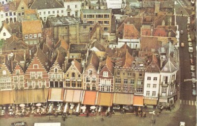
In Flanders the old cities of Bruges and Ghent were once harbors on southern distributaries in the Scheldt delta. They owed their development in the later part of the Middle Ages to their marine location and the wool provided by the herds of sheep which wandered over the surrounding sandy plain with its cover of heather. Moreover, flax grows well in this climate, and it helped the Flemish textile industry to attain great fame. The increase of population arising from these conditions called for more intensive land utilization, and in recent centuries crops have supplanted pasturage in extensive areas. Only in the Campine to the cast did sheep retain their economic importance, but even there they have now largely given place to meadows and cropland.
The cities of Flanders have had a checkered history. The silting of their harbors caused Bruges and Ghent to lose their importance during the last part of the Middle Ages, and thus Antwerp on the open stream of the main Schelde became the leader. Foreign rule, however, and the closing of the way to the sea by the Dutch Republic broke the power of Antwerp until the nineteenth century. Freed then from political impediments, it obtained a new lease of life and adjusted itself to modern conditions. It now serves an extensive hinterland and is one of Europe's great harbors, rivaling Rotterdam and Hamburg. A canal through one of the Dutch isles of Zeeland gives it a waterway to the Rhine and provides an inland line of communication so that the Belgian flag is frequently seen on the Rhine boats.
The ancient textile industry also revived during the time of the Industrial Revolution, although most of the raw material has to be imported. Ghent is again a great center of cotton and linen manufactures. Bruges never regained its former greatness and is a quiet but beautiful city, where lacework is carried on as a home industry. Tournai, farther south, forms a kind of stepping-stone to the textile area of northern France. The wool industry, formerly so important, has shifted towards the plateau north of the Ardennes with Verviers in the extreme east as the main center.
3. The Loamy Upland. --This next region occupies the center of Belgium, and extends from the French border to the Meuse River. As in northern France, a widespread and fertile cover of loess makes this the best agricultural region of Belgium. The relief is rolling and in the west there are small hills, relics of former escarpments. Some of these became famous during the World War as strategic points for the defense or capture of which thousands of men were killed, as at Kemmelberg near Ypres. Fields of wheat, barley, oats, and sugar beets as well as orchards and vegetable gardens, surround the many villages. The population is dense, and there are many towns which serve as centers of trade and culture, for example, the university city Leuven (French Louvain). But all roads on this upland lead to Belgium's great capital, Brussels. Because of circumstances that were largely political, this chief city of the Province of Brabant chanced to become the seat of government during a period of foreign domination, and gradually overshadowed the Flemish cities. Having become the capital of Belgium in 1830, it continues to be the most important city, the very heart of Belgium. Essentially French in culture in spite of its location north of the language boundary, it resembles Paris in many respects. Industrial development has followed on political importance, but there is little specialization. The Willebroeck Canal connects Brussels with the Schelde, and small seagoing vessels can reach the city.
In the southern part of the upland along the Sambre-Meuse River, which follows the soft coal layers at the foot of the Ardennes, a great manufacturing development entirely overshadows agriculture, and from the French border up to Liege the landscape is dominated by factories. Coal has been the basic factor in this industrial development. The coal syncline crosses the country from France to Germany, forming the Sambre-Meuse depression. Exploitation is not always easy, for the coal seams are thin, the geological structure is in some places very complicated, and the quality of the coal is not the best. Superior resources are found in the Campine at greater depth, but exploitation is here still in its infancy. For the iron industry foreign coal of suitable quality has to be imported in large quantities, a disadvantage which is partly offset by the export of coal from Belgian mines.
The mining of iron ore, which was once important, is now insignificant in comparison with the large import of that commodity from French Lorraine. The southeastern corner of Belgium has a small share of the great Lorraine iron-ore deposits, but the neighboring mines of Luxembourg are of greater importance. Their value is enhanced by the nearness of the German coalfields which have given rise to a number of smelters. The pig iron here produced is mostly exported. Zinc, also, used to be exploited near the German border, but is now imported as ore from foreign countries.
The Sambre-Meuse industrial zone can be subdivided into three sections. The western section--the Borinage--around Mons is essentially a coalmining region. The next district, that of Charleroi, in connection with its coal output has developed metal works, machine factories, chemical industries, and the manufacture of glass which is a Belgian specialty. In both sections industries are more scattered and are carried on in smaller towns than in England. Even Mons and Charleroi are comparatively small. This industrial development continues along the Meuse River to the third section, with the old town of Namur at the confluence of the Sambre and the Meuse as one of the centers. Only farther north, however, around Liége, does it again take on great significance. During the nineteenth century, the ancient city of Liége became the center of a great industrial region, with the usual iron works and machine factories as well as zinc smelters and glass plants, notably those producing fine crystal.
4. The Ardennes. --The remaining three regions may be grouped together as the Ardennes and its foreland. This low mountain region, or old plateau, belongs to the ancient Hercynian system. After being eroded to a peneplain in the course of tens of millions of years, it was uplifted during the Alpine period. Its highest elevations, reaching some 2,000 feet, are found in the east, and the plateau slopes down towards the northwest with a somewhat abrupt drop of 300 to 700 feet between the real Ardennes and the Ardennes foreland or Condroz region. The northward continuation of the Ardennes block lies buried under the young deposits and loamy soil of the central Belgian uplands. The rivers generally follow the inclination of the old peneplain, as the Meuse River which has eroded a narrow valley running northward till it reaches the soft coal layers outside the plateau, where it turns toward the east.
The Ardennes presents a strong contrast to the loamy upland in many respects. The Condroz foreland is, indeed, fairly productive, especially where it consists of limestone. There it supports rye, oats, and potatoes as the main crops, as well as considerable livestock, mostly dairy herds. But parts of it are covered with forest, and there the density of population is far less than on the loamy upland. The high part of the Ardennes with their oak forests and moorlands, where sheep-raising was formerly the chief rural industry, is still Belgium's least-developed region. Even here there has been a rapid change. Forests still cover great areas (about a quarter of the region), but the number of sheep has declined and on every hand are meadows and fields of rye, oats, potatoes, and forage crops; cattleraising, too, is gaining in importance.
The climate of the Ardennes, including the part in Luxembourg, shows the influence of high elevation as well as of increased distance from the sea. The higher parts have cold raw winters; the depressions have fairly warm and rather dry summers.
The small southwestern section of Belgium belonging to the limestone region of the Lorraine escarpment is mainly devoted to rye and oats, but does not show the intensive cultivation of the western regions. Luxembourg can be divided into two sections: the northern part, belonging to the Ardennes upland, produces little and is mostly forest land; the southern section, along the Lorraine escarpment, has fertile soils where oats, rye, and potatoes are abundantly grown, and even grapes can ripen.
Source: Europe
|
|
This website is created and designed by Atlantis International, 2006
This is an unofficial website with educational purpose. All pictures, and trademarks are the property of their respective owners and may not be reproduced for any reason whatsoever. If proper notation of owned material is not given please notify us so we can make adjustments. No copyright infringement is intended.