|
|
New York - New York City - Manhattan
 It's a tight little island, 12 ½ miles at its longest, 2 ½ at its widest, covering 14,211 acres, rising from its surrounding rivers to a height of about 268 feet near Fort Tryon Park, and standing at about latitude 40° N., longitude 73° W. 1,537,195 persons were listed as living here in 2000. 200,00,000 commuters traveled into and out of town by way of Manhattan's 20 bridges, 18 tunnels, and 17 ferries. It's a tight little island, 12 ½ miles at its longest, 2 ½ at its widest, covering 14,211 acres, rising from its surrounding rivers to a height of about 268 feet near Fort Tryon Park, and standing at about latitude 40° N., longitude 73° W. 1,537,195 persons were listed as living here in 2000. 200,00,000 commuters traveled into and out of town by way of Manhattan's 20 bridges, 18 tunnels, and 17 ferries.Transportation within Manhattan is furnished by rapid transit systems of subways and elevated lines, by street surface railways, by busses carrying and by the 13,087 taxicabs licensed to operate in the borough in 2006.
Two districts, the first lying between the Battery and City Hall, the second bounded by Twenty-third and Fiftieth Streets and lying approximately between Ninth and Park Avenues, contain a high percentage of blocks. It was estimated that 62.6 per cent of Manhattan's land was used for residential purposes and 22.9 per cent for nonresidential. Nearly all the remainder, 14.25 per cent, is given over to parks, of which there are 93 with a combined area of 2,303.897 acres.
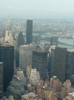
For most visitors to New York City, the center of interest is the Borough of Manhattan, the most explosive center of civilization in the New World. The borough is an island 12½ miles long, shaped like an index finger pointing to the south.
Manhattan streets are laid out on the gridiron plan, with avenues running north and south, and cross-town streets running east and west, from river to river. All cross-town streets are numbered, except those south of Houston Street and some in Greenwich Village, where the gridiron system was not applied. The avenues are also numbered, but include a few with names: Lexington, Park, and Madison Avenues, and Broadway. Fifth Avenue, which begins at Washington Square, divides the cross-town streets into east and west sections and is the starting point of house numbers on those streets.
The designation "downtown" refers to. a direction south of a given point; "uptown," north. These terms, together with "midtown," apply also to approximate sections of Manhattan: downtown, from the Battery to Fourteenth Street; midtown, from Fourteenth to Fifty-ninth Street; uptown, north of Fifty-ninth Street.
Lower Manhattan
Area: Battery on the south to 14th St. on the north; Hudson River to East River.
Principal north-south streets: Broadway, West St., Hudson St., Varick St. (and 7th Ave.), 6th Ave., Chrystie St. (and 2d Ave.), Allen St. (and 1st Ave.). Principal cross streets: Fulton St,, Chambers St. (and New Chambers St.), Canal St., Broome St. (and Delancey St.), Houston St., and 14th St.
The flat lower end of Manhattan, between the Battery and Fourteenth Street, is the oldest section of the city and the richest in historical associations. Today it has become a commercial, financial, and industrial center where steamship docks crowd one another, and ferries, subways, elevated lines, bridges, and traffic arteries converge and spread fanwise, distributing people and merchandise to every section of the Nation.
In the extreme south is the Battery and Whitehall district, in whose skyscrapers, overlooking the Goddess of Liberty and the ships that pass out to sea, are concentrated the executive offices of transatlantic lines, of exporters and importers, and of consular representatives of foreign nations. West Street, fronting the Hudson River, and edged with busy docks, is the main highway for the city's incoming and outgoing supplies. On the Lower West Side are the produce markets, the dark streets of Manhattan's Syrian colony, and numerous warehouses interspersed with tenements.
BROADWAY, the longest and most fantastic street in the world, starts its 16-mile journey from the tip of Manhattan as a shipping lane, moves a few blocks north to the Wall Street financial center, passes by the civic buildings of the city, and takes a diagonal course from Union Square through the needle-trades area between 34th and 39th Streets. Between 42d and 53d Streets, Broadway is the Great White Way—renowned as an amusement and theatrical center. From 53rd Street to Columbus Circle it cuts through Automobile Row, center of the auto retail trade. It changes its diagonal course at 79th Street to parallel the island's high escarpment facing the Hudson River. Here it is lined with hotels, apartment houses, cafeterias, beauty salons, movie houses, and churches. At 114th Street it strikes a new note in the buildings of Columbia University, and another at 155th Street in a group of museums. From this point on it is a nondescript thoroughfare, ending as a semisuburban road as it approaches the city's limits.
BATTERY AND WHITEHALL DISTRICT
Area: South of Battery Place, Beaver St., and Old Slip.
The Battery, threshold of Manhattan, spreads in a decided arc along the North River shore at the southernmost extremity of the island, where East and North rivers empty their sediment into the Upper Bay. West Street, rumbling with the trucks that serve almost a hundred North River docks, extends northward from the Battery. Massive blocks of office buildings and the structure that carries the final stretch of the Ninth Avenue el fill the rest of the northward view until, at the northeast corner of the park, Bowling Green opens out in an irregular plaza; from here Broadway cuts a clean northbound way through the towering stonework of the lower island. Squared ponderously against Bowling Green, south, is the U.S. Custom House. North, nearest the river, is the Whitehall Building. The name "Battery" derives from a British fort built along the river in 1693.
The curve of the present el on the park's east border and Pearl Street, extending east, mark the original shore line. The rest of the area is filled-in land. Beyond the el structure are State Street and the conglomerate skyscraper contours that mount toward Broad and Wall Streets. At the southeast corner of the park opens the great plaza of South Ferry, where all forms of Manhattan's transportation -- subway, el, ferry, bus, and taxi -have a compact major terminus, and where the heavy traffic artery, South Street, opens out opposite, bordering the docks to the east.
|
|


This website is created and designed by Atlantis International, 2006
This is an unofficial website with educational purpose. All pictures, and trademarks are the property of their respective owners and may not be reproduced for any reason whatsoever. If proper notation of owned material is not given please notify us so we can make adjustments. No copyright infringement is intended.